THE FRONTIERS AND TOWNSHIP LINES OF THE COUNTY 1750-1785
overing the years 1762-1769, displays it even further. Further encouraging to settlement was the Treaty of Fort Stanwix, signed N ovember 5, 1768, which marked the final defeat of the Indians by British forces. The terms of this treaty gave more than half the land earlier returned by the Easton treaty to Pennsylvania, which attached it to Cumberland County. The added area is shown on the map by the use of a border of concentrated small dots. For the second time the county extended to modern Ohio, but this condition was even more temporary than the one after the Treaty of Albany.When the Proprietary government organized into townships the territory purchased by treaty from the Indians on October 11, 1736, transferring "all the said River Susquehanna with the lands lying on both sides thereof," east to the head of the river's tributaries, west "to the setting of the sun" and from the mouth north "to the hills or mountains called Kekachtanemin" and an Octo-ber 25, 1736, when the Indians confirmed that the earlier treaty included "all the lands on both sides of the River Susquehanna from the mouth thereof as far northward... to the ridge of Hills called Tyoninhaschta," they made most of what is now Cumberland County Pennsborough Township and the area on the Frank-lin County line Hopewell Township. The name Rathmullan Township appears in very old deeds for locations now in Franklin County, and its relationship to Hopewell is difficult to determine. No other change occurred in Pennsborough prior to the erection of Cumberland County in 1750 except the split into East and West, which is reflected in the lists of collectors early in the 1740s. Hopewell, however, grew rapidly, and by 1751 what is now Franklin County con-tained several townships.
After the county was organized, it remained legally confined until the era of the French and Indian War, although the Scots-Irish in the population made efforts to break into Indian lands. On July 6, 1754, in the treaty at Albany, more than half of what is today Pennsylvania at an instant became Cumberland County. The treaty line shows on a map two pages ahead, which is intended to show the county in the colonial era: beginning on the river ,between today's Snyder and Union Counties, it ran straight to the Warren County border with New York. If the line had been confirmed, part of New York would have been organized within Cumberland County. The circumstances of the treaty, however, were protested by the Indians, and in the treaty signed at Easton on October 23, 1758, under terms engineered by Pennsylvania Quakers, most of the new territory reverted, and the line was changed to the one labeled on this map as the "limit of Cumberland County from 1754 to 1768.11 In the meantime, the colonial claim of Maryland to a line that now runs through Franklin County was settled by Mason and Dixon's survey in 1767. The Virginia claim was maintained until after Bedford County's creation.
The development of the county was at a standstill in 1754-1758 and 1763-1765 because of the Indian wars. The earlier of those two periods saw such a high level of Indian hostilities that the 1758 reversion had the effect of confirming the existing limits of settlement. Complicating matters were fires at private residences of persons holding official records. One, at the Carlislt residence of Capt. Robert Callender in 1759, destroyed some papers of Col. Henry Bouquet, the new commander of British forces in the province. We will never know whether land information was lost, but Bouquet parceled out land in the Bushy Run area four and five years later on the strength of his commission. In 1763 the home of the county deputy surveyor, Col. John Armstrong of Carlisle, was burned. Frequent references to the con-sequences of this blaze appear in the early Cumberland County deeds. The list of Cumberland County warrantees which appears in Series 3, Vol. 24 of the published Pennsylvania Archives illustrates the spurt of settlement which came about in 1762, and the West Side Applications record at the State Archives,
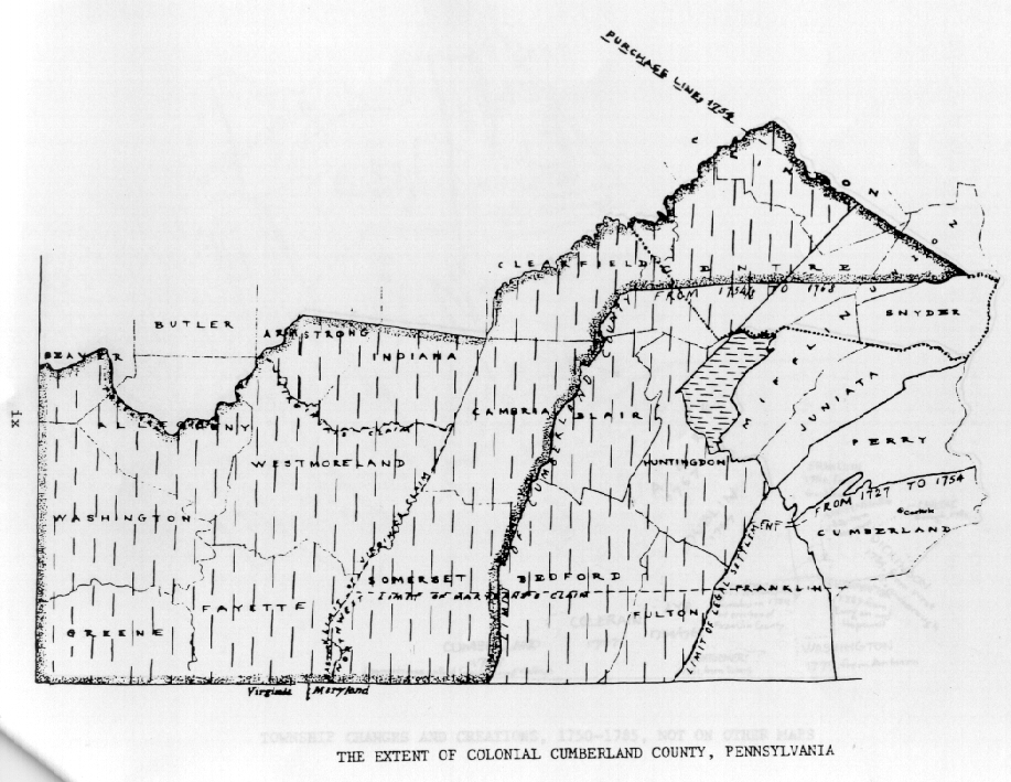
The second of these maps[above] presents the county in the Revolutionary War era, between the creation of Bedford County (March 9, 1771) and the close of Deed Book G in 1785. The first map has features which belong to the later period. A bold line runs up the west edge of Franklin County, cuts into Huntingdon County, then goes due northeast into Clinton County. Everything west of that line is marked by vertical broken lines representing territory which was cut from Cumberland to create Bedford County. The area lost by Cumberland County was palpably greater in area than that added by the 1768 treaty. On March 21, 1772, when Northumberland County was erected, Cumberland ceded the remainder of the area outlined in bold dots. The region in Huntingdon County marked by horizontal broken lines is the Barrg District, which was disputed until finally assigned to Bedford County on September 30, 1779. The only other frontier change of Cumberland County within the period covered by this volume was that occasioned by the erection of Franklin County on September 9, 1784.
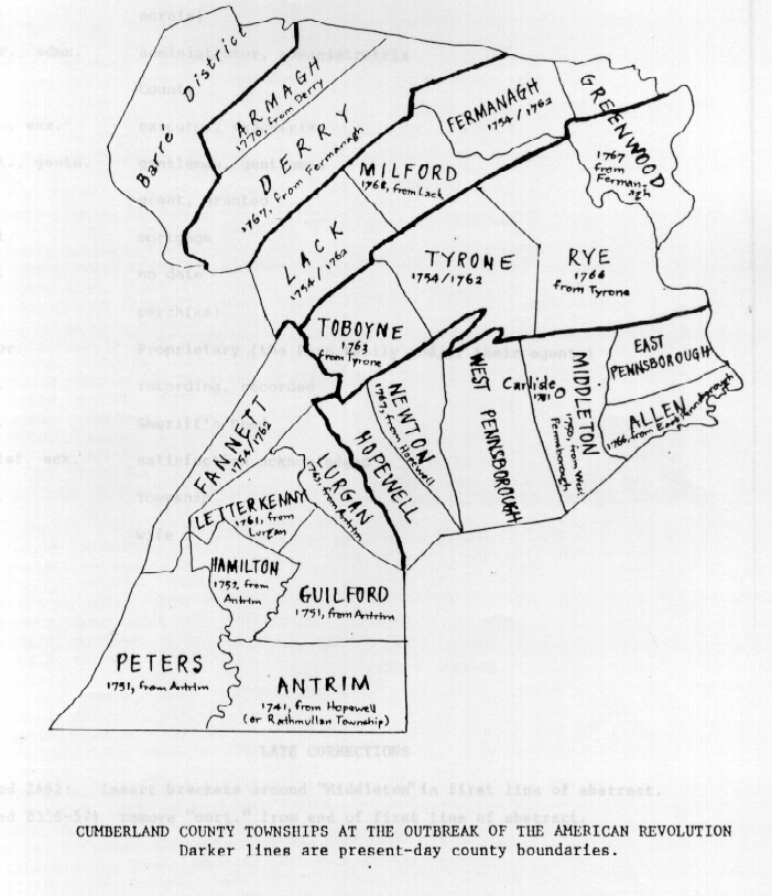
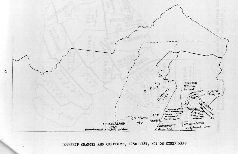
While counties are organized on the basis of provincial and state legislative acts as approved by the head of government, townships in Pennsylvania have not always been documented in any fashion. The state published Incorporation Dates of Pennsylvania Municipalities in 1965 and filled it with references to passages in county histories as documentation for the creation of many townships and some boroughs, sometimes giving conflicting information that had been found in more than one history in order to provide a notion of the date the municipality began to exist. The township lines and dates on the accompanying maps are given as well as can be ascertained from many varied sources and seem to hold up in general when compared to the historical records from the period.